Talk:Land of the Giants
Not AvLee[edit | hide | hide all]
In MM7, we visit the Land of the Giants, and it is depicted as part of Eeofol, with Kreegan main base being there, as well as numerous titans and dragons. No mention is ever made of LotG being part of AvLee, neither in H3 or MM7. Furthermore, in MM7 it is called "the mountains south of AvLee", specifically distinguishing one from another.
In RoE campaign map a small piece of LotG border is shown, colored black, like the Nighon border on the island. This correlates with the Lost Lore mention of Nighon "controlling" Eeofol (as assumed by Erathian when in reality, it was an alliance, which Kreegans later abandoned) and the MM7 mention of Nighon diggin a tunnel. Note, however, that while Lost Lore talks about Nighon having territory on the eastern shores, it doesn't limit it to LotG specifically, though it is apparently counted among that.
I rephrased the Nighon mention in the article. Also, we don't exactly know that LotG was part of the halfling homeland specifically. They sure are part of the same geographical region, but it's not stated that there was a halfling presence in LotG itself, although this is not disproven, either. I think it should just be mentioned that LotG is part of Eeofol, with the Eeofol article mentioning halflings.
When showing the HotA map of Antagarich, I suggest we color the LotG region red like the western, Inferno part of Eeofol, while keeping the border black. That would reflect both LotG being part of Eeofol, as well as Nighon having influence there and in other areas in that part of the eastern coast. But LotG definitely shouldn't be colored green or listed in the AvLee regions table.
As an aside, I think we should also somehow mark that Antagarich map as HotA-exclusive when it appears in articles. BTW, note that the region names on the HotA map don't always reflect the entire marked portion. For instance, it is entirely possibly LotG is smaller than what is marked on the HotA map: from canon sources we know that includes the peninsula directly east of the Inferno Eeofol, but the portion to the north might as well be just part of Nighon. The general position of the LotG region on the HotA map is correct (and we do know that Nighon generally has holdings on the eastern shore, so it may include that), of course. Also, names like Erathia Plain or Bracada Mountains are not from NWC sources, they were mostly put there to name these areas something. --XEL (talk) 09:03, 20 July 2025 (UTC)
- Ah, great. This was actually on my list of things to talk to you about (see Proposals > Lore > New Features). I was leaning toward coloring it as Nighon to honor the Lost Lore, but could be convinced to go with the Eeofol red like you described. I could also color it with slashes like a contested area that is claimed by 2 countries, then add it to the navigation menu for both Eeofol/Nighon. I probably should do this for the Contested Lands as well... --Legate (talk) 12:17, 20 July 2025 (UTC)
- We're moving it from the AvLee regions table to the Eeofol one then? --XEL (talk) 13:10, 20 July 2025 (UTC)
- Hmm, I just now got your point about looking at the ROE campaign maps (including the part mostly blocked by text). Here are the ones I found that show the Nighon holdings (see notes on hover-over):
- Side note: Do you know if more complete/filled in maps exist? I have never come across them.
-
 Dungeons and Devils
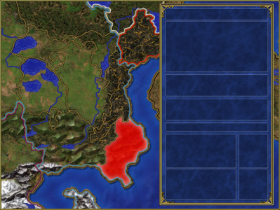
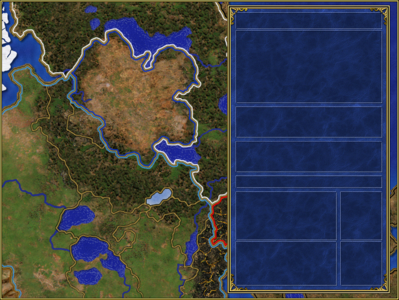
This shows LotG as part of Nighon -
 (ignore) Long Live the Queen
(same as DAD) -
 Liberation
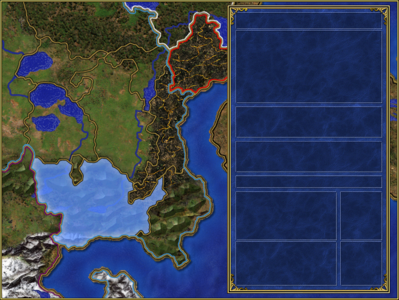
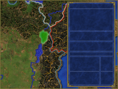
slightly clearer picture showing LotG as Nighon -
 Long Live the King
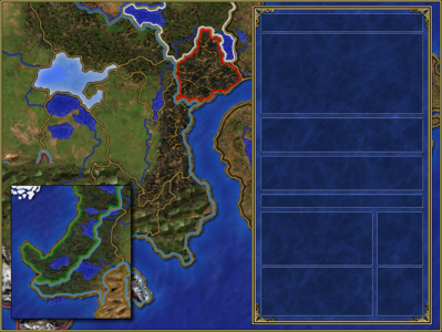
This one surprised me. It shows the Nighon holdings going all the way up the AvLee coast! -
 (ignore) Song for the Father
(same background a LLTK) -
 Seeds of Discontent
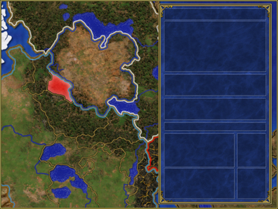
Seems to be missing an AvLee-Nighon border around the LotG


Yes, these RoE maps are what what I was referring to when talking about Nighon holdings on the coast. BTW, Dragon's Blood (campaign scenario) apparently takes place somewhere in that part of the coast north of LotG, as it features a border area between Nighon and AvLee. No full H3 map with nation borders exists, only the borderless map (which the HotA campaign map was based on). There is a monochrome map of Antagarich included in a guide to MM7 which does have borders, but these are regional borders. On that map, the strip of land on the eastern coast extends all the way to the northern tip of the continent. However, national borders are not marked, and MM7 confirms that this strip of the coast doesn't entirely belong to Nighon, because Pierpont is located by the eastern coast.
Agreed, moving LotG to both Nighon and Eeofol region tables is a good idea. --XEL (talk) 09:52, 22 July 2025 (UTC)